Showing posts with label hiking. Show all posts

Jul 4, 2015

Bonneville Shoreline Trail

I discovered, quite by accident, one day that the trail referred to as the upper canal trail is actually a portion of the Bonneville Shoreline Trail. The happiest part of this part is that it's only a short UP-hill jaunt for me access it.

I usually only walk a small portion but THIS-day I wanted to explore uncharted territory. And can I just say how much I love Google maps? I love knowing where I am on the map! (You know... the little *You Are Here* circle?)


I successfully maneuvered the transition from my regular route to the continuation of the trail. Last fall I got off on the wrong trail and had quite the mountain goat adventure.


And Harley? Oh yes! He is my partner in crime. He loves our daily walks but he especially appreciates THIS route because it is the only time I let him off the leash to explore. I talk to him like he's a little child, "You stay where you can see me or you will have to go back on the leash!" Interestingly enough, he seems to understand and only rarely goes beyond my sight.

Several times this trail merges with the power line road. But for the most part it is narrow like the photo above.


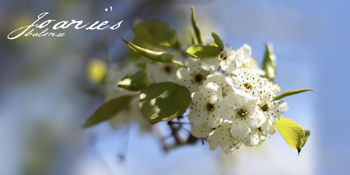
I spotted this happy little face brightening up its little corner of God's masterpiece. I'd never seen one of these before (except in my niece's photos from her nature walks).


The first hour we were in the shadow of the mountain and it was quite comfortable. Soon we emerged into the hot July sunshine.


These are my new *trainers*. I absolutely love the Go Walk by Skechers!  They have saved my poor plantar fasciites feet.  I credit this wonderful shoe, in various colors and styles (*if the shoe fits, buy it in every color!), with helping in the healing of this last bout (well, that, and losing 23lbs!)


We hiked 2.6 miles north-west along the trail when I could see that the trail was diverging more from the houses just below and the next opportunity to get off the trail wasn't until 970 N. Since I didn't want to make that long trek back through town we turned around and started back the way we came.

I knew there was a shortcut back down to the houses so we alternately took deer trails, and did some slipping and sliding down the dried grass hills to the street.

Oh Snap! I knew wrong! See all of the squiggly streets about a third of the way down the trail?


Yeah, let's get a close up of that! I was shooting for Spring Creek Dr instead of Spring Oaks Dr. I didn't want to go up that step climb again (You can even see how steep it is on the map!)


We (read Grammie) just didn't have the energy to take that long asphalt detour so we mountain-goated it again... only this time I slipped on my bum (hey, not so bad) and then another slip that pulled a muscle in my thigh! But, not to worry, I still had over a mile walk home so I worked that stiffness right out!

The happy news about this alternate route is that it got us back down to sprinkler water. Our water was all drunk up! Harley drank his fill and I filled my water bottle. (Note to self... take your camel-back next time!)

We were both glad to get back home and take a bath; well, Harley not-so-much. It wasn't until evening, when I saw him licking his front paw and investigated expecting to see a fox-tail I'd missed in the bath.

What I saw was...

THIS!

I've only seen this once before on a dog when we took Amber to Vasquez Rocks and she wore blisters on her little padlettes on the sandstone!  Poor Harley! I felt so bad!

By bedtime these were MY stats for the day...


Harley easily did one third more with all of his up & down and  back & forth. Poor boy had to take a rest day today...

but no rest for the Grammie. I had my 10,000 steps by noon.

Nov 8, 2014

Mountain-Goat Grammie

Earlier this week a friend posted a photo of her and her walking buddy, Cooper, on the trail that runs above our houses- the Bonneville Shoreline trail. It looked so glorious that it tempted me right out of the house and up onto the mountain.

I grew up right at the base of the mountains in our little town in the Indian Valley, California. I used to take off and explore all over the mountains. It always refreshes and rejuvenates me to take a hike (which is different than a walk!)


Harley could hardly believe his good luck! I never let him off the leash when we go on walks. But since this was a hike and we were up the mountain I told him he needed to stay where I could see him or he'd have to go back on the leash. (Yes, I talk to him like he's a person... a little person in a hairy-suit!) He understood and was quite obedient to my conditions; well, most of the time.

We hadn't gone far when the view opened up across the valley to Utah Lake with the cerulean sky overhead.


At this point I couldn't tell where the trail went next... silly me, I should have just looked on Google Maps on my iPhone which clearly shows the trail. So I doubled back and headed up the side of the mountain on a mountain goat deer trail.

I wanted to get up to the power lines and survey the fire damage (which is almost imperceptible after the wet September we had). I quickly realized that this mountain goat trail went up and down each of the gullies that one almost doesn't perceive when looking up on the mountain. After one such gully I was seriously doubting the wisdom of where I was (what if I tumbled down the mountain and had to call for a rescue? Now that would be embarrassing!) and decided that I needed to just start down hill until I hit the real trail again.

There is a lovely rock that was just right for resting on. I spied out my house. It was easy since my other neighbor has a wonderful bright red tree in her yard.


I'm always surprised at how a camera diminishes distance. This photo doesn't reflect how far this Grammie had hiked!


I've often thought I'd like to hike to the top of this mountain... but not this day!


We got back home just as the light was turning all golden and lovely.  We'd had a happy outing on this golden, stolen November day!

MY SITTING ROCK.
I know that all too soon we will have snow and it will be months before this kind of hike will be possible.

Oct 8, 2014

Yosemite National Park- A Heritage Vacation- Day Three

Thursday we planned for a mule ride! I was very excited about this bit of reenactment! I've ridden a mule once before, at Mammoth Lakes in 1994 but apparently it was an atypical, cooperative mule! I love Grandad's description of mule riding...
"Every day we hiked to points of interest. The falls were nice and full in July and we explored them all as far as we could go. This [the trail to Glacier Point] is the trail over which the guides take their tourists by horse- or mule-back. We kept pace with them almost all the way up the trail; sometimes we would pass them and later they would pass us sitting down to rest. A mule is a very aggravating animal, especially on the trail. The guide would be up in front, mounted on a horse, and occasionally a mule would spy a nice green sprig off to one side of the trail, and the rider couldn’t stop him from getting it—which as very uncomfortable to the rider, who would have a hard time to keep from sliding backward out of the saddle. When this occurred in the middle of the line, it caused quite a jam and the guide would have to come back and get the mule to change his mind again. We saw one old fellow in this kind of a fix and he hollered bloody murder until the guide righted his mule again."
We were set for a 4-hour trail ride that started at 8 am. We needed to arrive early to watch their safety video and get our mandatory riding helmet. There were only 5 riders this day, plus the two guides. They had the mules all lined up on one side of the hitchin'-fence and told us to wait on the other side (the safe side) until we were matches up with our mule. Imagine my surprise and delight when they said, "Joanie, this is your mule, Elsie!" I won't lie... it brought tears to my eyes. What were the chances? Just a coincidence? I THINK NOT!!


Rebekah got paired with Melvin. We were assured by our guides that none of the mules were suicidal and to trust them. I loved watching Melvin's little mincing steps as he maneuvered his way on the trail, keeping my acrophobic daughter safe... even in the face of sure death!


But it was a close thing. About three-quarters of the way up the steep mountain trail the mule right in front of me stepped on the side of the trail as it maneuvered one of the many hairpin turns, knocking loose some rocks, which, naturally started a mini rock slide. Welp! Elsie decided to take exception with that! (And if you've ever been horse or mule back riding, you know what I'm talking about!) That 16-hand-tall mule turned on a dime that would make any good cuttin' horse jealous and started tearing off down the trail away from that evil mass of rock wedging her way between Melvin and Rebekah on the inside, uphill side of the trail pushing her puny friend and rider right up to the precipice of death!! Luckily I am an experienced horsewoman (oh, but mules are a different breed!) and was able to stop her in quick time.

Rebekah mentioned that her leg and knee hurt but it wasn't until later that we saw the extent of the damage... and this is before the bruising started to bloom.


But Bek cowgirled-up and we had a lovely view from the top.


We wanted our guide to capture our likeness, just like Bill and Elsie 102 years ago, but Elsie-the mule is a big girl...


and we needed a better vantage point so we could even see Rebekah and Melvin.


The stables are right at the base of Royal Arch, where Grandad and Grandma camped those many summers ago.
When we checked in at the Ranger’s Station, we were assigned to Camp 8 which is under the Royal Arch, which is within walking distance of Camp Curry, where they had an entertainment each evening, which was climaxed by the fire-fall from Glacier Point each night. Glacier Point is about 3,000 feet above the floor of the valley and each day they make a big pile of wood which is lighted in the evening and when it burns down, the embers are pushed over the precipice—thus the fire falls. Midway down the face of the cliff is a ledge upon which the embers fall and burn themselves out. A person at the top of the cliff cannot throw a stone or stick hard enough to fall on the valley floor, for the draft will suck it in so that it falls on the ledge every time.
ROYAL ARCH AS SEEN FROM GLACIER POINT

And it is where my mom, Elsie, was conceived.

ROYAL ARCH AS SEEN FROM VALLEY FLOOR


No trip to Yosemite would be complete without a photo of El Capitan!


And Grandma Elsie thought so too.


We saw several climbers scaling the face. We pulled out my 70-300mm zoom lens and could see them toiling bravely weighed down with way too much stuff! And, what, may I ask does one do when they have to go potty in the middle of a climb? It take two days and they sleep in a hammock set-up over night. Just one more reason I won't be doing any rock climbing!

And that's it... our wonderful heritage vacation. We had a lovely time. It was just the right amount of time.


And it only took us 2-3 days to get over the soreness of hiking and mule riding!

**
If you'd like to read more of Grandad's history you can find it here. The story about their Yosemite vacation begins on page 17.


Oct 7, 2014

Yosemite National Park- Mirror Lake- Day Two

After our jaunt up to Glacier Point we wanted something where we could stretch our legs. One of the park employees suggested Mirror Lake and that was just right for us! I could hardly wait to see this beautiful sight 102 years later!


We should have invested in a Yosemite map but thought we could get by with the map provided for free. Next time! We ended up on a mule trail that was quite rough and littered with evidence of recent mule activity!


The scenery was wonderfully beautiful hiking along next to these rock-a-dons. I needed to add this photo for perspective!


When we were almost to Mirror lake we saw these two rock cairns. Another park visitor informed us that there were about an hundred just around the corner.


But all I could think of was getting to the lake and putting my feet into the nice cool water...


Erm... do you think the park employee could have mentioned this tiny detail? This is all that is left of Mirror Lake. A sign informed us that there is always a cyclical pattern to Mirror Lake's size but this year it was ALL beach-front property... WITH NO WATER! (So sorry to my achin' little piggies!)

We noticed a middle-aged couple lying on the fine gravel of Mirror Lake's dry bed gazing up at Half Dome. We decided to follow suit and rest my piggies, at least!

John Muir stated that he felt like he was in a huge cathedral when he was in Yosemite. I have to agree with him. I felt such a sense of reverence in this wonderful specimen of God's handiwork.


Our return trip was much easier as we took the bike trail but completely forgot to go looking for the hundreds of rock cairns! Silly girls.

Sep 27, 2014

Yosemite National Park- Glacier Point- Day Two

Tuesday night we didn't even eat dinner until 9 pm so we had a slower start this day. Our first stop was Glacier Point.

It is at Glacier Point that the is the famous Over hangin' Rock! (BTW the handwriting on these photos is my Grandma Elsie's hand.)

 (El's handwriting)

The more I learn about my Grandad, the more I understand where my impulsive behavior comes from!


And, you know, this IS a heritage-reenactment vacation...


But, surprisingly, I've learned to be cautious in my 60s (I want to see my 70s and 80s). So this is my version of Bill Munce on over hangin' rock! (Taken the day before at Olmsted Flats) Also, the rock is fenced off and folks are not allowed to go out there any longer.


One of Bill and Elsie's first stops was Inspiration Point. Aren't they so darling? Inspiration Point isn't too far from Glacier Point.


I have to say that my favorite of all the places we visited was Glacier Point! The views from up there are wonderful!!

HALF DOME AS SEEN FROM GLACIER POINT
(update 2107- this photo now hangs in my front room)

Grandad says of their hike to Glacier Point-
Our longest hike was to Glacier Point by the long trail, which skirts Vernal and Nevada Falls. It is 13 miles and that was tough going in some places. But the climb was well worthwhile, for from Glacier Point you can look straight down onto the floor of the valley. The stages looked like toys as they rolled along the road and the people looked as big as dolls. We went into the restaurant up on the Point and had our meal out on the porch, which was glassed in and was nice and warm. From here we could look out all over one side of the valley and it was marvelous. Vernal Falls is only a short distance away, maybe a mile, and it is so clear and bright you almost felt as though you could touch it. Nevada Falls is further back, but it completed a beautiful picture.

We returned to the valley by the short trail, which was 3 miles long and all downhill. This was only a narrow foot trail and animals were not allowed on it. It was unimproved and in a great many places the going was tough, on account of the rocks and deep gullies, and if you think your feet won’t get sore getting jammed into the toes of your shoes every step, just try it. Our feet and ankles were sore for a week.
YOSEMITE VALLEY AS SEEN FROM GLACIER POINT

Several years ago Rebekah and family took Camille to Yosemite on one of her summer visits. Rebekah, Camille, Tadhg and Caden ended up taking the hike down (and according to Grandad, straight down!) from Glacier Point to the Valley... IN FLIP-FLOPS! Bek says they got a lot of strange looks that day! Curtis and baby-Brock met them at the bottom. We decided we would forgo this reenactment since it cost $25 each for a bus ride to the top. Happy little Elio took us there for only a sip of gasoline!

HALF DOME AS SEEN FROM GLACIER POINT 2014

HALF DOME 1912


I will be back tomorrow, or the next, with more of our Yosemite adventures. I'm having such a good time remembering!

Sep 21, 2014

Yosemite National Park- A Heritage Vacation- Day One

Several months ago I gave a Primary sharing time about family history and shared a trip that my grandparents made to Yosemite in 1912. That started a hankering in my soul that needed to be satisfied. I knew that at 62 I would finally qualify for my Senior America the Beautiful pass. So with those two pieces of information I cooked up a Yosemite trip with Rebekah (who lives an hour away from Yosemite). I just wanted to go back needed to make a heritage vacation with Bill and Elsie in mind.

They traveled by horse and wagon and it took them 4 days to make the trip from Fresno to Yosemite. They camped near where their great-granddaughter would one day live on the second night.


We traveled from Yosemite Lakes Park, where Bekah lives, in Elio and made the trip in about one hour. But that first glimpse of Yosemite Valley is still just as breathtakingly beautiful.


Since there isn't an easy way from Bek's house to Utah (every route is 13 hours!) they frequently cut through the Park and then head out across Nevada and Utah on Hwy 6. They are always in a hurry to leave or get home when they pass through Tuolumne Meadows and don't take time to stop. We decided that would be would be our first destination. On our way we stopped at Olmsted Point for our first hike.


My beautiful Bekah... she kindly hiked at my Grammie pace.


Our next stop was Tuolumne Meadows. We hiked around the meadows, not across, and back to the Tuolumne River. The river was unusually low due to the severe drought affecting California.


The temperature was much cooler here, for which we were grateful.

I'll be back in the next few days to post more about our adventures.